Browsed by
Category: Blog

Ancient urban alignment leads LiDAR investigation to new site

Ancient urban alignment leads LiDAR investigation to new site

By Alexis Bridges, Tanya Catignani y Ariel Texis Muñoz

At Teotihuacan the use of detailed satellite imagery and LiDAR technology has allowed for remote detection of archaeological features which are often impossible to see at ground level. It affirms that we can neither escape the legacy of the past nor the influences that it has on our present.

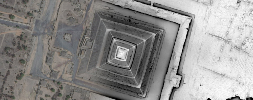
One of the goals of the Project Plaza of the Columns Complex this season has been to determine how much of the present-day Teotihuacan Valley was influenced by the ancient alignment of 15 degrees east of true north. Our team tracked this alignment by digitizing modern features in ArcGIS Online (Figure 1). Because the Avenue of the Dead is so central to the city, it seemed logical that nearby modern structures would be aligned in the same configuration, and areas farther away from the city center would less likely display this pattern. Our results abiding by the strictest of calculations revealed that more than 30% of the region does match this traditional alignment, even areas that are far away from the city center. One theory for this is that ancient structures, long crumbled and buried over the centuries since their initial construction, may have  influenced contemporary building and agricultural decisions by raising complications of digging and plowing around these archaeological features.

Figure 1: Satellite map of the Teotihuacan Valley with digitized modern features. Site TC-8 is located at the center-left.

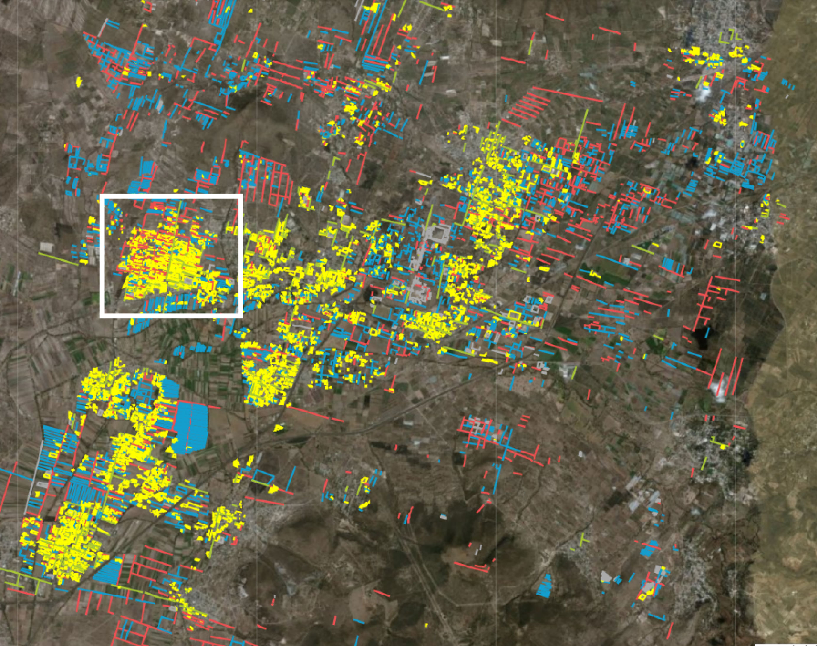
One town in particular that drew our attention lies to the west of the city center (see Figure 1). Nearly all of the town is aligned, resulting in a massive hotspot of digitized features on the map. However, the LiDAR and satellite maps did not reveal any obvious archaeological features in the area. After studying old archaeological reports, we found that this location had, indeed, been previously excavated. In the 1960s William T. Sanders discovered an apartment compound capable of housing hundreds of people at its peak occupation and was inhabited at least until the Colonial period (Figure 2). Although Sanders’ team identified this site as TC-8, the eighth site associated with the Teotihuacan Classic period, his site map lacked identifiable features that could have led us to the excavation site.

Figure 2: Site drawing of TC-8 by Sanders team (The Teotihuacan Valley Project).

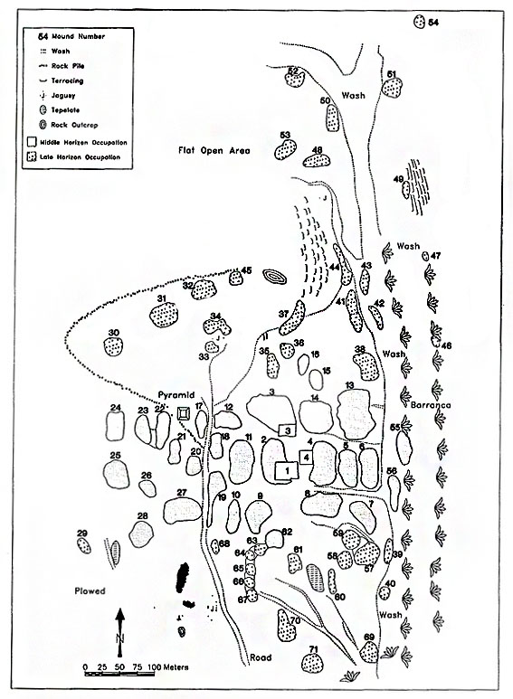
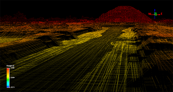
Despite this, Sanders created a second map that charted the entire valley, fortunately safeguarding sites that may have disappeared over time. A rough location of the site was found by georeferencing what streets and towns still existed. From there, a rock alignment could be seen on the LiDAR map as well as very, very slight mound formations that closely matched with the ones identified on Sanders’ map (Figure 3).

Figure 3: LiDAR digital elevation map (DEM) showing the mounds at TC-8.

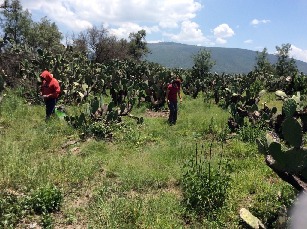
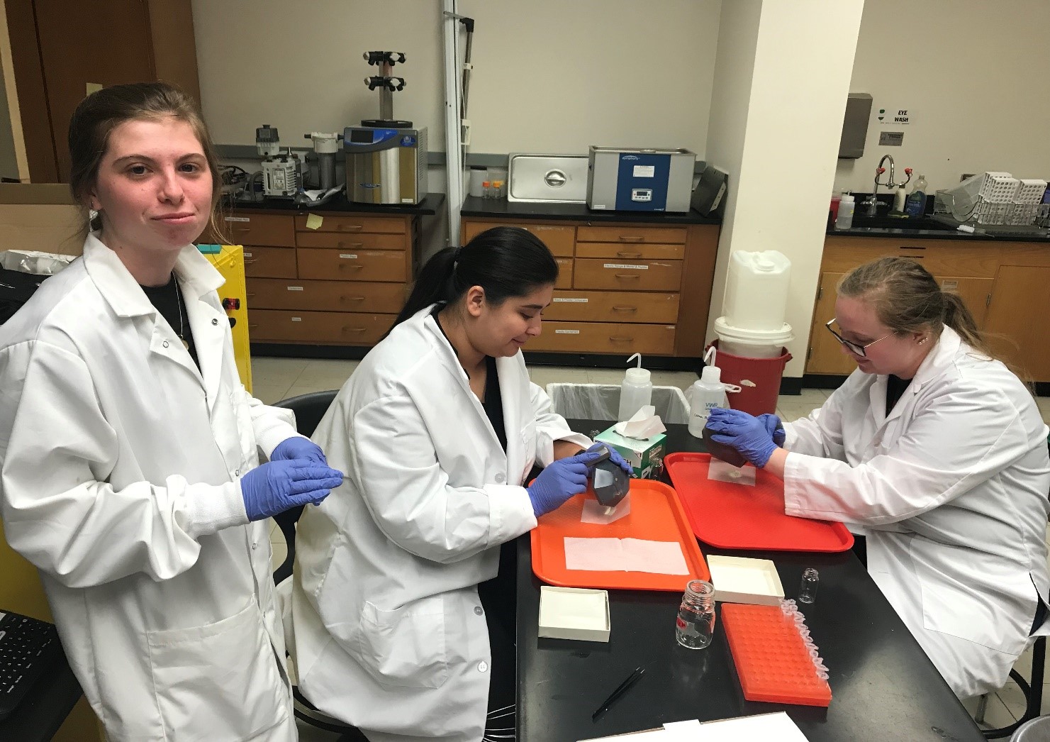
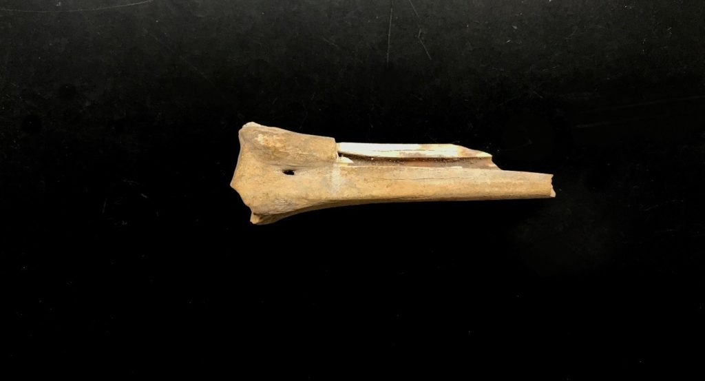
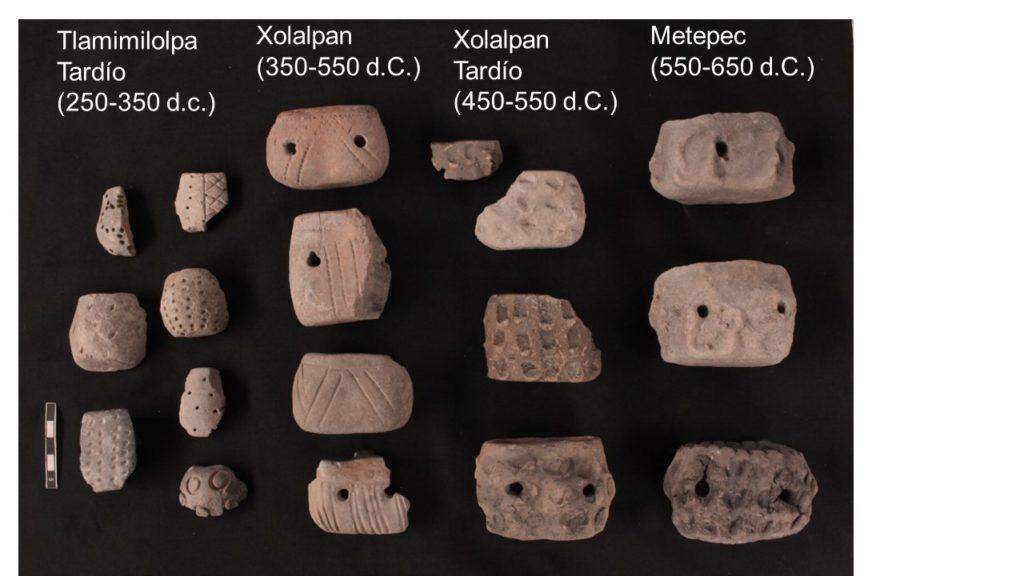
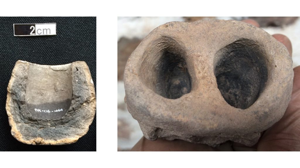
Preliminary ground truthing has yielded promising results of pottery sherds and shell fragments  ̶  an unusual find for an inland area. Using a similar process, another site in the southwest known as TC-21 was also located with similar finds of ceramic sherds. Although these preliminary results are not confirmation, they do indicate that our locations may be these previously forgotten Sanders’ sites.            

This experience highlights the power of combining modern technology with historic data. Technology without the analog aspects of archaeology cannot show us everything, and relying entirely on technology will create a loss of data. The re-discovery of TC-8 and TC-21 only shows that archaeology is, and will likely remain, a historical science at its foundation.

LiDAR

LiDAR

LiDAR technology (Light Detection and Ranging/ Laser Imaging Detection and Ranging), is a remote sensing method that uses a device that measures different surfaces of the earth, to analyze various forms of geographical structures and architectural structures. Emitting a laser that measures and records the distance between the emitting device and the object that reflects the emission, LiDAR technology creates three-dimensional information about the shapes and surfaces from scanning the cultural and natural features. The device works as an airborne scanner, firing thousands of laser emissions per second and recording “returns” to the device; creating a “point cloud” that allows for the analysis of the data points and is also geographically referenced.

Avenue of the Dead and Moon Pyramid: LiDAR point cloud.

The data points obtained from LiDAR technology create a three-dimensional model of the earth’s surface but also the various man made and natural features that cover the land that it hovers over: including but not limited to viewing  density of vegetation, agricultural features, ancient structures, modern structures, and land use. One of the great advantages of this technique is that the data processing makes it possible to “eliminate” the vegetation layers (virtually) that covers the land and to obtain a detailed “portrait” of the land surface, creating a Digital Elevation Model (DEM). A Digital Elevation Model (DEM) is a three-dimensional model of the surface that is formed from the elevation data, obtained by LiDAR technology in this case. The degree of detail that these types of digital maps and images have is greater than that which could be obtained by traditional surveying, in addition to saving a lot of time and work force. LiDAR was first used by scientists and mapping professionals, but now a days has been incorporated into the research of other disciplines as well.

Sun Pyramid: aerial photograph (left) merged with DEM image (right).

Recently, LiDAR technology  has been incorporated into archaeological research complementing traditional methods of surveying lands such as aerial photography and simply walking/recording sites manually. The LiDAR data is referenced to the Global Positioning System (GPS) that collected data and information can be geographically referenced. Technological advancement has allowed for high resolution images to be created and has reduced degrees of error, that now the registration of the features or elements detected on the LiDAR map are calculated in centimeters.

At the Teotihuacan Valley, the Project Plaza of the Columns Complex generated a LiDAR map in 2015. The map covers an area of ​​approximately 165 km2. The local vegetation does not interfere with the surface of the investigated area, instead modern structures (urban areas) dominate the valley today covering ancient remains.  Instead of working through vegetation, the challenge is to know what is ancient and what is modern. The LiDAR map is unique in the region and presents a portrait of the valley in 2015, where the centuries of changes to its surface are being be recorded and compared to older surveys in the area.

Teotihuacan Valley LiDAR Map over aerial photograph (© PPC, Informe Temporada 2018).

In 2017, a special team was appointed to work on surface exploration. The objective of the team has been to ground truth the Teotihuacan Valley, to search and verify each of the data sets recorded on the LiDAR map of 2015. The team has concentrated on walking surveys, taking samples of the materials visible on the surface and verify the accuracy of the LiDAR map, to distinguish between what may be ancient and modern elements. Establishing relationships with local communities has been essential to understand how the modern areas of occupation have formed.

The surface survey has two teams, one that works in the laboratory and one that works in the field.. First, members of the team analyze the LiDAR map to detect possible ancient features and  name them as potential elements in the laboratory. The potential elements include features such as depressions, mounds,  plazas, structures, or terraces. Second, members of the team are responsible for verifying the potential elements in the field, a survey method known as ground truthing. With the help of geographical positioning devices (GPS), the team go to the precisely marked geographic coordinates on the map to collect materials and samples on the surface and record the areas. The members of the team cross compare the material in the field with the map, to infer ancient vs. modern occupancy.

In this case, a specific area is delimited, collecting ceramic fragments, obsidian, clay figurines and polished stones such as metates and manos. Furthermore, a detailed record of the elements, on the present vegetation, the current land use, and the presence of other materials are taken carefully. Everything that is collected is labeled and taken to the laboratory, where it is cleaned, washed, and marked by specialists. Ceramics and lithics specialists analyze and prepare materials and samples for preservation.

Teotihuacan Valley: collecting cultural materials.

This type of work carried out in the Teotihuacan Valley would not be possible without the support of the local communities, they are the ones that give us permission to walk on their fields, agricultural lands, “ejidos” and other properties. Communication is vital, as we are all united in the effort to preserve and study cultural heritage and history. In addition to the permits, provided by the government, to carry out the research. Local communities and residents provide personal knowledge about their land; narrating stories about past and changes that have occurred recently, and/or the old names of some places (such as the different hills that surround the valley). Communicating with local communities and residents provided us with information beyond the digital maps alone. We thank the following communities and residents for their unconditional support of our research:

  • Atlatongo (Palomar)
  • Barrio de Purificación
  • Belén
  • Cozotlán
  • Cuautlazingo
  • El Saltito
  • Ixtlahuaca
  • Maquixco
  • Oxtotipac
  • San Agustín Actipac
  • San Antonio de las Palmas
  • San Francisco Mazapa
  • San Isidro
  • San Lorenzo Tlalmimilolpan
  • San Lucas Tepango
  • San Pedro Tepetitlán
  • San Sebastián Xolalpan
  • Santa María Palapa
  • Santiago Tolman
  • Santiago Tepetitlán
  • Tlachinolpa
  • Tlajinga
  • Xometla

Furthermore, we want to thank the municipalities (Acolman, San Martín de las Pirámides, Teotihuacan de Arista, and Otumba), “Reino Animal” Conservation Center, and the Texcoco Delegation of the Secretary of Environment of the State of Mexico. We thank you for the attention you have given, the collaborative effort in understanding the history of the area,  the permission to grant permits, and ongoing support for this research project.

The Elements of a Paleodiet: How Isotope Analysis Help Archaeologists in the Lab

The Elements of a Paleodiet: How Isotope Analysis Help Archaeologists in the Lab

by Esther Aguayo

Food is an important part of our lives, yet it is a difficult thing to see in the archaeological record. Usually archaeologists rummage through ancient trash piles to look for animal bones and residues in pots to find out what people ate. However, there is another tool that archaeologists use that can tell us more about what people and animals consumed called stable isotope analysis. This methodology helps archaeologists understand the chemical make-up of human and animal bones to reveal information regarding diet, social organization, and human-animal interactions. At the Archaeological Sciences Lab at George Mason University, I help prepare bones in order to extract that information.

All living organisms are comprised of molecules that they have absorbed or eaten throughout their lives. Bones, teeth, and even hair molecules can tell archaeologists a lot about an organism’s life history and environment. These molecules, referred to as stable isotopes, and their composition can vary depending on the environment of the organism. Factors such as temperature, altitude, nutrition, and humidity affect isotopic composition and will be reflected in the tissues we look at. There are several isotopes that can be analyzed such as carbon, oxygen, nitrogen, and strontium. 

Carbon is most familiar as the lead in our pencils and what we breathe out in carbon dioxide, but carbon also relates to the way plants obtain energy or photosynthesis. C3 and C4 cycles are the most common photosynthetic pathways a plant can use and can be determined from bones of an animal or person who ate plants. Since photosynthesis varies among plants, archaeologists can reconstruct what people and animals were eating, where they lived (based off where the plants grew), and how their diet changed over time. This is the information that can be deduced from carbon alone. It is important to collect the information stable isotope analysis provides. So, how do archaeologists conduct isotope analyses?

An archaeological deer bone with a piece removed for isotope analysis.

In the Archaeological Sciences Lab I help prepare the bones to extract the isotopic information we need. The bones from the Project Plaza of the Columns Complex (PPCC) are cleaned after excavation. Then, the bones are analyzed, identified to species, photographed, and documented for further reference. It is important to document the bones well because isotope analysis is a destructive process. First, I make sure the bones are cleaned completely. Using a hand rotary tool, I thoroughly clean off any excess dirt and build-up on and inside the bone. I also use the rotary tool to remove a part of the bone that will be used for the isotopic analysis. Then, I wash the bones in a sonic bath which uses high frequency sound waves to remove any remaining dirt that cannot be removed by hand.

Isotope samples ready to be soaked overnight.

After letting the bones dry overnight, I use an agate mortar and pestle to crush the bones into a fine powder. I weigh each sample and transfer them to tubes so they may soak overnight in a chemical solution to begin the removal of organic components. Then, the samples are rinsed in ultrapure water, and an acid solution is used to completely remove all organics in the sample. Once weighed a final time, the sample is ready for the mass spectrometer at the Smithsonian Museum Conservation Institute. The mass spectrometer is able to measure isotopic variations in a sample. It is through those variations that archaeologists can gain insight on the diet of the individual and the ecosystem they lived in.

Adding a chemical solution to remove organic material from the bone powder.

At first glance, isotope analysis is intimidating to someone with little experience with heavy machinery and chemicals. However, since working at the Archaeological Sciences Lab, I have greatly enjoyed my time learning about isotopes and the many questions about ancient life that can be answered through this process. Stable isotopes open a new window into ancient life that tell archaeologists about more than just food consumption. At the PPCC, isotope analysis has helped investigators find out more about animal management and how it had affected social structure in ancient Teotihuacan. The potential use of isotope analysis is quite vast, and archaeologists still have much more to discover using this fascinating methodology.

References:

  1. France, Christine A.M., Douglas W. Owsley, and Lee-Ann C. Hayek. “Stable Isotope Indicators of Provenance and Demographics in 18th and 19th Century North Americans.” Journal of Archaeological Science 42 (2014).
  2. Schwarcz, H.P, M.J. Schoeninger. “Stable Isotopes of Carbon and Nitrogen as Tracers for Paleo-diet Reconstruction.” In Handbook of Environmental Isotope Geochemistry, by M. Bakaran, 725-742.
  3. Sugiyama, Nawa, A.D. Somerville, M.J. Schoeninger. “Stable Isotopes and Zooarchaeology at Teotihuacan, Mexico Reveal Earliest Evidence of Wild Carnivore Management in Mesoamerica.” Plos One 10, no. 9 (2015).
  4. Sugiyama, Nawa, William L. Fash, and Christine A.M. France. “Jaguar and Puma Captivity and Trade among the Maya: Stable Isotope Data from Copan, Honduras.” Plos One 13, no. 9 (2018).
  5. White, Christine D. “Stable Isotope and the Human-Animal Interface in Maya Biosocial and Environmental Systems.” Archaeofauna 13 (2004). 183-198.
What can be learned through pottery analysis?

What can be learned through pottery analysis?

The case of candeleros

by Yolanda Peláez Castellanos

The potters who made the ceramic pieces recovered in archaeological excavations gave them different shapes depending on the function they would have (e.g., pots and bowls were used in the preparation and consumption of food). A very distinct form that corresponds almost exclusively to Teotihuacan can be seen in the figure below; these vessels have been found in various foreign sites, and each have been attributed to Teotihuacan presence or influence.

Candeleros from distinct phases (photograph by Fredy Álvarez)

These vessels are small and can have one (4x5x4cm) or two (5x8x5cm) cylindrical chambers, the latter usually having lateral perforations. In the Colony Period they were called candeleros (“candlesticks”) because the indigenous people reused them to support candles (Ceballos 1992: 205-206), but these did not exist when the city of Teotihuacan was inhabited.

The analysis of the candeleros gives us information about them (Peláez 2018):

PRODUCTION

– When examining the pieces, you can see the technique that was used to decorate them (e.g., punching, incision, fingerprints).

– More time was spent in the production of some pieces (e.g., it takes longer to manufacture a candelero with a polished lip like those of the Xolalpan phase than one with fingerprints like those of the Metepec phase).

– The method of making and decorating them has changed over time. Based on physical attributes, they were classified into three phases considering the parameters of an already established chronology (Rattray 2001). Accordingly, this indicated that the production of candeleros lasted for a period of approximately 400 years (250-650 AD). (See Ceramic Analysis, Relative Chronology)

USE

Some visible features give us clues about the use of the candeleros:

– The dark traces in the chambers indicate that something was burned inside them.

– Charred organic remains were found inside some of the tested chambers.

Candeleros with evidence of burning (photograph by Fredy Álvarez)

In order to determine the substances that these artifacts may have contained, their chemical residues were analyzed. These residues are stored in superficial pores where liquid or semi-liquid substances might have spilled. If this action (of use) was repeated or if a large amount of matter was deposited, some components present in these solutions can be identified (i.e., phosphates, carbonates, proteins, fatty acids, carbohydrates, and pH can also be measured) through tests called spot-tests (Barba et al. 2008: 721; Barba et al. 2014: 202-204). This type of methodology is also used for soil chemistry analysis (Barba et al. 1991).

Not all the candeleros demonstrated a discernible amount of residue, but the combination of components that were identified was interpreted as moderate combustion of cellulose, presence of substances of animal origin, and combustion of resins (Peláez 2018). This is consistent with the results of other investigations (Ortiz 2006).

DEPOSITION

The location where the materials were found in excavations sometimes corresponds to the place where they were discarded and not necessarily where they were used, although it is feasible that they were used in the vicinity and in various locations in Teotihuacan. In large part, the candeleros have been found associated with domestic spaces.

Most of the analyzed PPC candeleros (77%) came from Front C. It was originally hypothesized that this area was domestic, although so far only rooms have been found west of Mound 25Z and north of Structure 26A. The presence of candeleros supports the idea that this area could have been residential.

Excavation units with the presence of candeleros and percentage of sample present per front(Map data ©PPC, modified by Yolanda Peláez)

References

Barba, Luis, Roberto Rodríguez, y José Luis Córdova

1991      Manual de técnicas microquímicas de campo para la arqueología. Instituto de Investigaciones Antropológicas, Universidad Nacional Autónoma de México, México, D.F.

Barba, Luis

2008       Los residuos químicos en cerámica. Indicadores arqueológicos para entender el procesamiento de alimentos y el uso de recipientes. In Quaderni di Thule VIII. Atti del XXX Convegno Internazionale di Americanistica, pp. 721-728. Centro Studi Americanistici Circolo Amerindiano, Perugia.

Barba Luis, Agustín Ortiz y Alessandra Pecci

2014       Los residuos químicos. Indicadores arqueológicos para entender la producción, preparación, consumo y almacenamiento de alimentos en Mesoamérica. Anales de Antropología 48(1):201-239.

Ceballos Novelo, Roque

1922      Candeleros. En La población del valle de Teotihuacan, Vol. 1, edited by Manuel Gamio, pp. 205-212. Secretaría de Agricultura y Fomento, Dirección de Antropología, México, D.F.

Rattray, Evelyn

2001      Teotihuacan: cerámica, cronología y tendencias culturales. Instituto Nacional de Antropología e Historia and University of Pittsburgh, México D.F.

Ortiz, Nidia

2006      El candelero: estudio comparativo sobre su función en Teotihuacan durante el Clásico, Epiclásico y Posclásico Temprano. Tesis inédita de licenciatura en Arqueología, Escuela Nacional de Antropología e Historia, México, D.F.

Peláez Castellanos, Yolanda

2018       Los candeleros del Complejo Plaza de las Columnas, Teotihuacan. Tesis inédita de licenciatura en Arqueología, Universidad de las Américas, Puebla, Cholula, Puebla.

Social media & sharing icons powered by UltimatelySocial