Teotihuacan
Teotihuacan is one of the most iconic archaeological sites in Mexico. Declared as a UNESCO World Heritage site in 1987, it continues to attract a large influx of tourists every year.
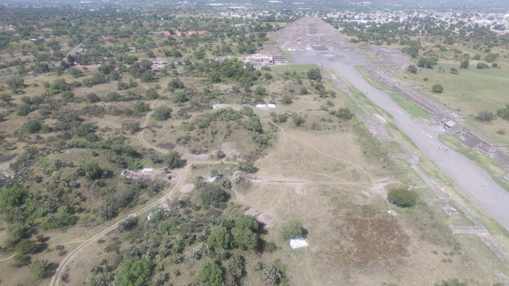
The ancient city of Teotihuacan is famous not only for its monumental pyramids but also because of the entire city’s precise and deliberate grid layout characterizing a grand urban planning scheme.
The ancient city of Teotihuacan is exceptionally captivating in the eyes of the public and researchers alike, perhaps due to the many unanswered questions that continue to surround this enigmatic culture. What was the dominant spoken language back then? What did the inhabitants call their city? According to sixteenth-century Spanish records/historians, Aztecs who once visited the site were the ones who bestowed the current name of the city. In their native Nahuatl language, “Teotihuacan” means “the place where men become gods” or “the city of the gods.” Awestruck by its scale, the Aztecs believed this sacred center to be where the gods created the fifth sun.
Previous investigations
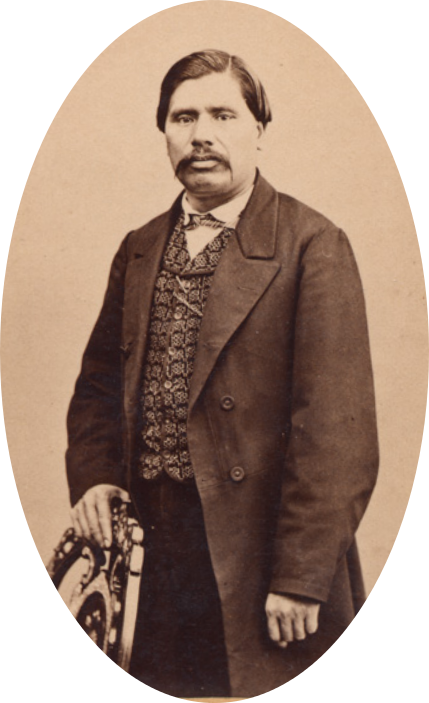
Carlos Singüenza and Góngora carried out the first excavation in Teotihuacan during the seventeenth century (ca. 1675; Schávelzon, 1982), and it is said that this groundbreaking event marked the first archaeological excavation in America. Two centuries later, Gumersindo Mendoza, a Mexican native from the village of Aculco, State of Mexico, undertook one of the earliest systematic studies at Teotihuacan. Mendoza’s 1878 publication “Las Pirámides de Teotihuacan” summarized and analyzed the available information regarding the pyramids, such as a general description of the area (vegetation, geological features, etc.), previous and current excavations and findings, dimensions of the pyramids, as well as an interpretation about the design and use of this ceremonial center. In addition, Mendoza proposed numerous hypotheses concerning the creation and destruction of the city, as well as who were the inhabitants of the city.
Click here to know more about Mr. Gumersindo Mendoza (Spanish).
In Mendoza’s day, the area where the Teotihuacan pyramids are located did not look like what we see now. In fact, most of the structures we see today were covered with soil and plants resulting from endless agricultural fields that once occupied the surrounding areas. Can you imagine what the pyramids must have looked like over 130 years ago?
To give you an idea, check out this 1878 painting by the famous Mexican painter Jose Maria Velasco:

From 1905 to 1910 Leopoldo Batres, Inspector of Archaeological Monuments, directed the first series of excavations and restoration projects at Teotihuacan. This project was set in motion to open the archaeological park to the public on September 13, 1910, celebrating the 100th year anniversary of Mexican independence. The site was inaugurated by the president of the nation, General Porfirio Diaz, and Secretary of Education, Justo Sierra, among other prominent figures of the time.

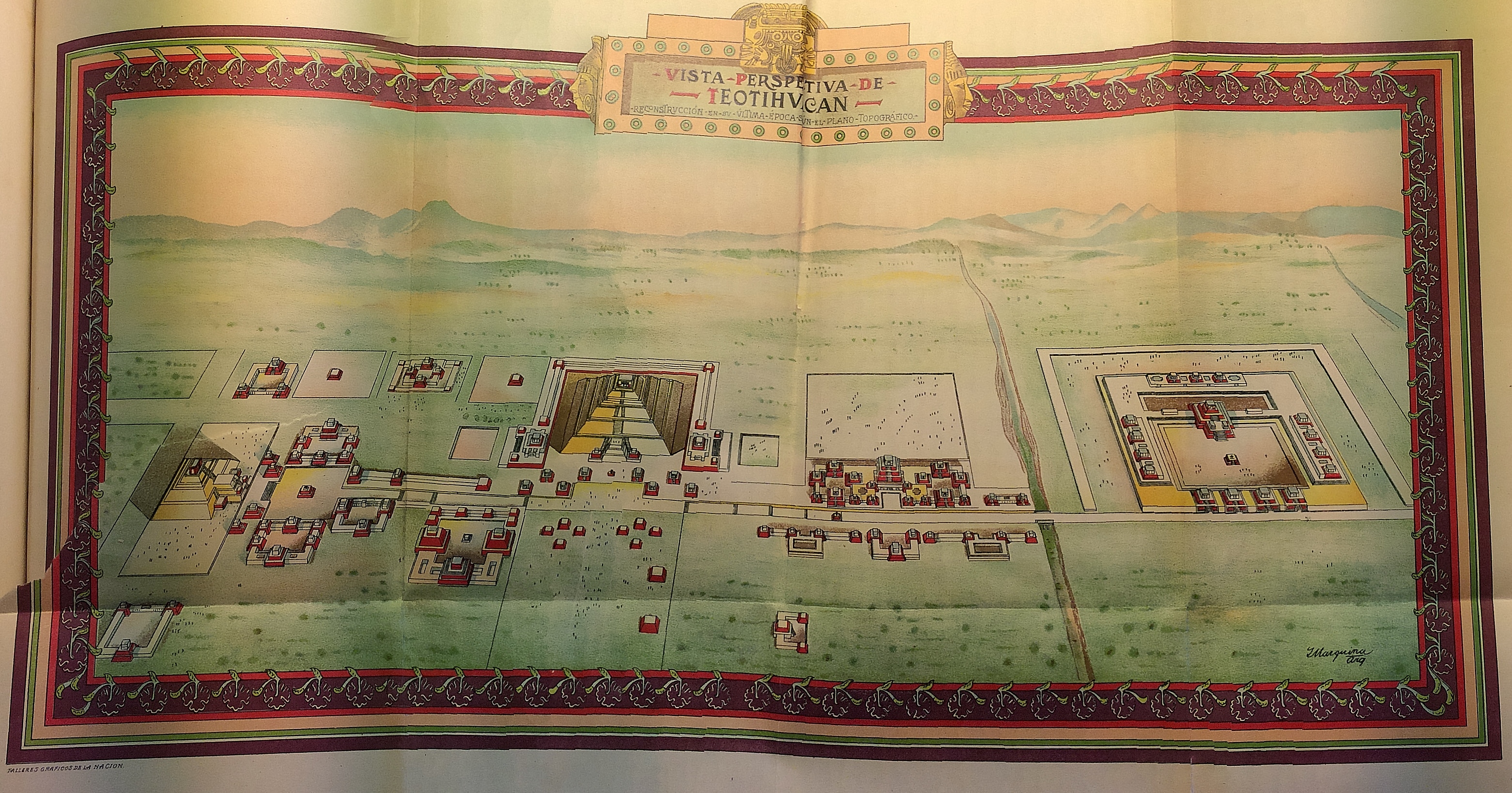
After Batres, several Mexican and foreign researchers continued intensive excavations and restoration projects in the areas surrounding the pyramids of Teotihuacan. Most notably, in the beginning of the twentieth century, Manuel Gamio and his collaborators carried out innovative investigations concerning the archaeological, cultural, geographic, and environmental setting of the Valley of Teotihuacan. The results of this first interdisciplinary work were published as a three-volume work called “La Población del Valle de Teotihuacan” (1922).
Below you can observe Gamio’s first reconstruction of the ancient city of Teotihuacan at the height of its occupation:
Between 1964 and 1970, René Millon from the University of Rochester, New York, assembled the Teotihuacan Mapping Project, integrating researchers from Mexico, the United States, and Canada. Their objective was to create the first detailed topographic map of Teotihuacan using aerial photographs and archaeological survey. In 1973 the results of the project were published in two volumes that included detailed maps of the city in unprecedented detail and magnitude, covering an area of over 20 square kilometers (or over 12 square miles).
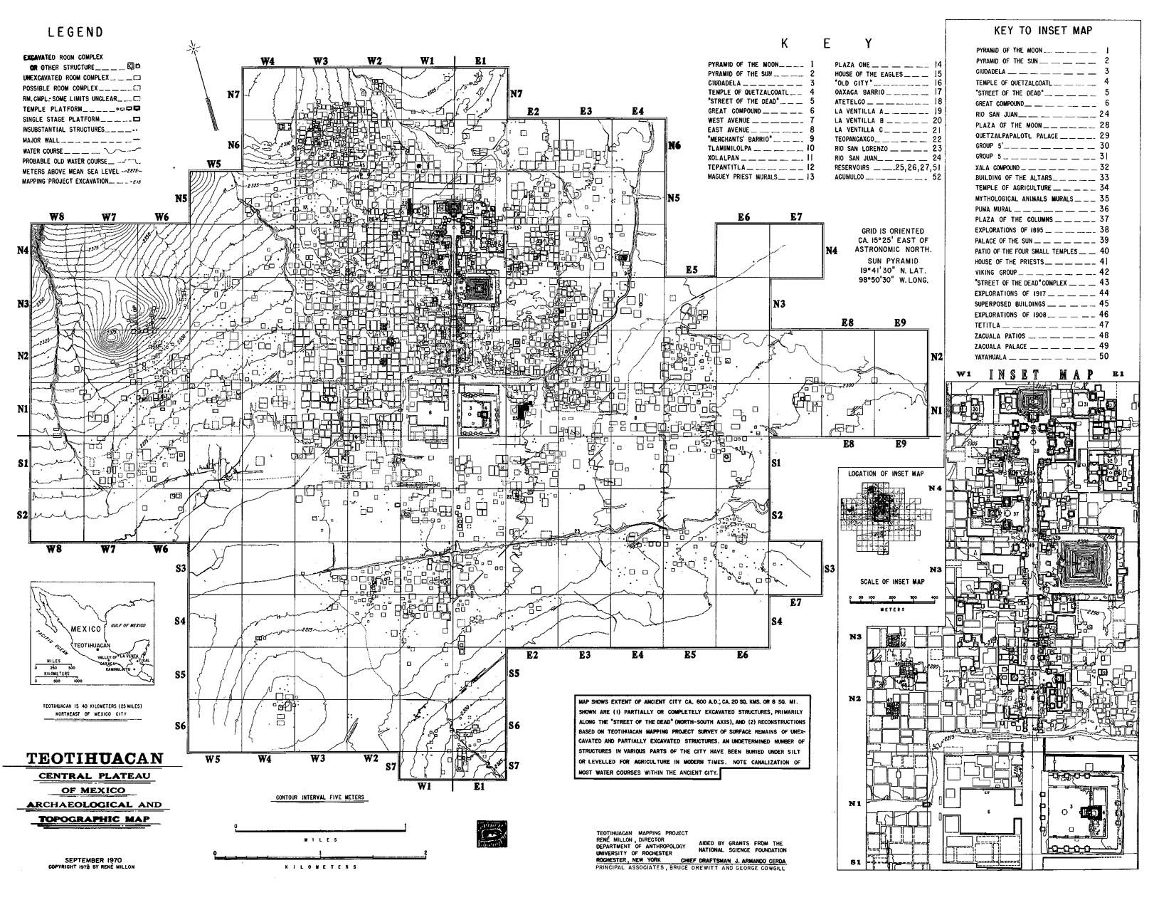
The project produced an exceptionally detailed map of the ceremonial area of Teotihuacan where the Sun and Moon Pyramids are located. Millon used results from the archaeological survey to propose a hypothetical reconstruction of the city, indicating the location of individual structures. This project uses the same nomenclature assigned by Millon (1973) to designate areas excavated in the Plaza of the Columns and the Plaza North of the Sun Pyramid.
To learn more about Teotihuacan, please visit the National Institute of Anthropology and History’s website at INAH where you can take virtual tours of the site. If you are able to visit Teotihuacan in person, make sure you take the time to explore some of the apartment compounds (like Atetelco, Tetitla, Tepantitla, etc.) where you will encounter their elaborate mural paintings (or wall frescos) that often are missed in the rapid tour of the monumental center. They form an important corpus of information about daily life Teotihuacan.
If you would like to know more about the ancient city of Teotihuacan, take a look at the Arqueología Mexicana, Special Edition No. 28: Teotihuacan, Periódico Cultural “La Vírgula,” and at the Periódico Mural “Tlalte Ollin” for many more interesting facts.
The city of Teotihuacan is located just 40 km northeast of Mexico City, so hop in a car or on a bus, and come visit the area. We guarantee you’ll love it!
References
Gamio, M. (Dir. de investigaciones, varios autores). 1922. La Población del Valle de Teotihuacan, el Medio en que se ha Desarrollado su Evolución Étnica y Social. Iniciativas para Procurar su Mejoramiento por la Dirección de Antropología. Tomos I, II, y III. Dirección de Antropología, Dirección de Talleres Gráficos, Dependiente de la Secretaría de Educación Pública, Mexico.
Iguíniz, J. B. 1912. Las Publicaciones del Museo Nacional de Antropología, Historia, y Etnología. Apuntes Histórico-Bibliográficos. Imprenta del Museo Nacional de Antropología, Historia, y Etnología, pp. 99.
Mendoza, G. 1878. Las Pirámides de Teotihuacan. Anales del Museo Nacional de Mexico 1: 186-195.
Millón, R. 1973. Urbanization at Teotihuacan, Mexico, Vol. 1, Part I: Text, pp. 154. Austin: University of Texas Press.
Millón, R., Drewitt, R., and Cowgill, G. 1973. Urbanization at Teotihuacan, México. Vol. 1, Part II: Maps. The Teotihuacán Maps. Austin: University of Texas Press. 147 map sheets + 3 folding maps.
Schávelzon, D. 1982. La Primera Excavación Arqueológica de América: Teotihuacán en 1675. Anales de Antropología I: 121-134. “Arqueología y Antropología Física,” del Instituto de Investigaciones Arqueológicas, Universidad Nacional Autónoma de México.