LiDAR
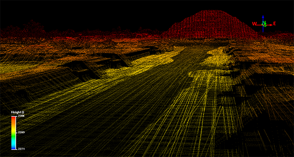
LiDAR technology (Light Detection and Ranging/ Laser Imaging Detection and Ranging), is a remote sensing method that uses a device that measures different surfaces of the earth, to analyze various forms of geographical structures and architectural structures. Emitting a laser that measures and records the distance between the emitting device and the object that reflects the emission, LiDAR technology creates three-dimensional information about the shapes and surfaces from scanning the cultural and natural features. The device works as an airborne scanner, firing thousands of laser emissions per second and recording “returns” to the device; creating a “point cloud” that allows for the analysis of the data points and is also geographically referenced.
The data points obtained from LiDAR technology create a three-dimensional model of the earth’s surface but also the various man made and natural features that cover the land that it hovers over: including but not limited to viewing density of vegetation, agricultural features, ancient structures, modern structures, and land use. One of the great advantages of this technique is that the data processing makes it possible to “eliminate” the vegetation layers (virtually) that covers the land and to obtain a detailed “portrait” of the land surface, creating a Digital Elevation Model (DEM). A Digital Elevation Model (DEM) is a three-dimensional model of the surface that is formed from the elevation data, obtained by LiDAR technology in this case. The degree of detail that these types of digital maps and images have is greater than that which could be obtained by traditional surveying, in addition to saving a lot of time and work force. LiDAR was first used by scientists and mapping professionals, but now a days has been incorporated into the research of other disciplines as well.
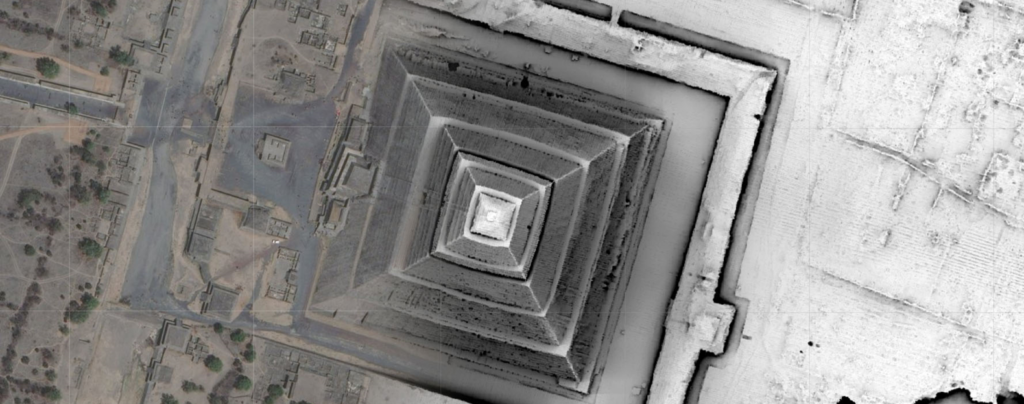
Recently, LiDAR technology has been incorporated into archaeological research complementing traditional methods of surveying lands such as aerial photography and simply walking/recording sites manually. The LiDAR data is referenced to the Global Positioning System (GPS) that collected data and information can be geographically referenced. Technological advancement has allowed for high resolution images to be created and has reduced degrees of error, that now the registration of the features or elements detected on the LiDAR map are calculated in centimeters.
At the Teotihuacan Valley, the Project Plaza of the Columns Complex generated a LiDAR map in 2015. The map covers an area of approximately 165 km2. The local vegetation does not interfere with the surface of the investigated area, instead modern structures (urban areas) dominate the valley today covering ancient remains. Instead of working through vegetation, the challenge is to know what is ancient and what is modern. The LiDAR map is unique in the region and presents a portrait of the valley in 2015, where the centuries of changes to its surface are being be recorded and compared to older surveys in the area.

In 2017, a special team was appointed to work on surface exploration. The objective of the team has been to ground truth the Teotihuacan Valley, to search and verify each of the data sets recorded on the LiDAR map of 2015. The team has concentrated on walking surveys, taking samples of the materials visible on the surface and verify the accuracy of the LiDAR map, to distinguish between what may be ancient and modern elements. Establishing relationships with local communities has been essential to understand how the modern areas of occupation have formed.
The surface survey has two teams, one that works in the laboratory and one that works in the field.. First, members of the team analyze the LiDAR map to detect possible ancient features and name them as potential elements in the laboratory. The potential elements include features such as depressions, mounds, plazas, structures, or terraces. Second, members of the team are responsible for verifying the potential elements in the field, a survey method known as ground truthing. With the help of geographical positioning devices (GPS), the team go to the precisely marked geographic coordinates on the map to collect materials and samples on the surface and record the areas. The members of the team cross compare the material in the field with the map, to infer ancient vs. modern occupancy.
In this case, a specific area is delimited, collecting ceramic fragments, obsidian, clay figurines and polished stones such as metates and manos. Furthermore, a detailed record of the elements, on the present vegetation, the current land use, and the presence of other materials are taken carefully. Everything that is collected is labeled and taken to the laboratory, where it is cleaned, washed, and marked by specialists. Ceramics and lithics specialists analyze and prepare materials and samples for preservation.
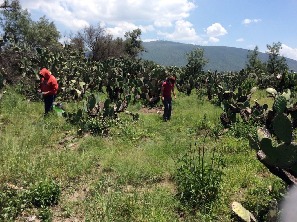
This type of work carried out in the Teotihuacan Valley would not be possible without the support of the local communities, they are the ones that give us permission to walk on their fields, agricultural lands, “ejidos” and other properties. Communication is vital, as we are all united in the effort to preserve and study cultural heritage and history. In addition to the permits, provided by the government, to carry out the research. Local communities and residents provide personal knowledge about their land; narrating stories about past and changes that have occurred recently, and/or the old names of some places (such as the different hills that surround the valley). Communicating with local communities and residents provided us with information beyond the digital maps alone. We thank the following communities and residents for their unconditional support of our research:
- Atlatongo (Palomar)
- Barrio de Purificación
- Belén
- Cozotlán
- Cuautlazingo
- El Saltito
- Ixtlahuaca
- Maquixco
- Oxtotipac
- San Agustín Actipac
- San Antonio de las Palmas
- San Francisco Mazapa
- San Isidro
- San Lorenzo Tlalmimilolpan
- San Lucas Tepango
- San Pedro Tepetitlán
- San Sebastián Xolalpan
- Santa María Palapa
- Santiago Tolman
- Santiago Tepetitlán
- Tlachinolpa
- Tlajinga
- Xometla
Furthermore, we want to thank the municipalities (Acolman, San Martín de las Pirámides, Teotihuacan de Arista, and Otumba), “Reino Animal” Conservation Center, and the Texcoco Delegation of the Secretary of Environment of the State of Mexico. We thank you for the attention you have given, the collaborative effort in understanding the history of the area, the permission to grant permits, and ongoing support for this research project.
Hi. I want more pictures of LiDAR to further complete our studies. What you are looking for is in the 2012 book called Nibiru Rediscovery, A Lopsided Mars and Ancient Longitudes by Richard A. Day, available on internet.
The layout and construction of Teotihuacan was precise. What a cool project to work on with LiDAR, especially with the geometric redundancies clearly indicating more in the cosmos than what we currently see with our eyes. Scientific American (May 2025) magazine hints at the orbit of another planet described at Teotihuacan, Nibiru.
Good luck and have fun.