How to Draw: Archaeology Version by Yolanda Peláez Castellanos Part 1: The Field Archaeologists are responsible for recording everything that they find as the materials could provide valuable research information not only about the context but also about past human activities. Once the materials are completely registered, they are removed from their original context. For that reason, it is essential to record as much information as possible out in the field. Field drawings are part of this registering process, and…
Read More Read More
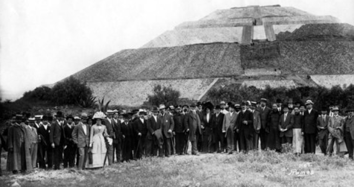
by Yolanda Peláez Castellanos Today, it is very easy to photograph and document the world around us. For example, people visiting Teotihuacan can take countless photos and share them on social media immediately; however, in the past, it was much harder to capture and reproduce images. The lithographs, paintings, and photographs from the end of the 19th century to the beginning of the 20th century demonstrate the many changes that the archaeological zone of Teotihuacan has undergone. Most of the…
Read More Read More
Come join us at the Society for American Archaeology’s 2021 conference. This year it will be online and our team members have prepared the following presentations: APRIL 16 8:30 am EDT – 7:30 am CDT Ariel Texis Muñoz, Tanya Catignani, Nawa Sugiyama and Saburo Sugiyama—Mapping Teotihuacan’s Inception: Patlachique Phase Ceramics Distribution on the Lidar Map 10:15 am EDT – 9:15 am CDT Teresa Hsu and Nawa Sugiyama—Playing with Your Food to Feed the Masses: A Zooarchaeological Perspective at Teotihuacan, Mexico…
Read More Read More
Analytical science: straight from the ground and to the laboratory Soil samples saved from the field are analyzed in the laboratory in order to recover plant and seed remains. The procedure for separating those tiny organic remains from the soil is called “flotation,” that is, where dried soil is gently sieved through a wire mesh with the help of some water. With this method, organic vegetable remains (including ancient ones that are usually carbonized or charred) float up to the…
Read More Read More